Machias Seal Island Lighthouse, US/Canada
- Feb 13, 2023
- 5 min read
Updated: Jul 14, 2024

You may be wondering why the title of this entry has both the US and Canada. This island is actually claimed by both countries. I tend to side with the Canadians on this one, despite being American, because at any given time there is always 1 person on the island: a Canadian lighthouse keeper, and there has been for over a century. Canada staffs the island with 2 keepers and they trade off every 28 days via helicopter. Although it's a solitary job, particularly in the winter, in the summer they are joined by about 10,000 birds, visiting scientists, and day-tripping birdwatchers and photographers.
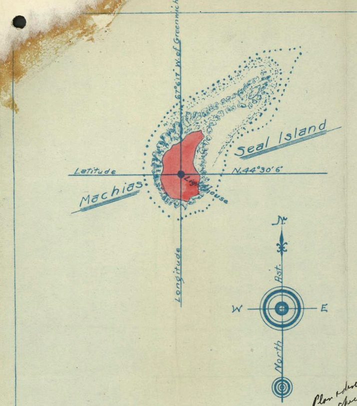
But how did all of this start? Machias Seal Island is certainly not a large island. In fact, it could fit inside of New York's Central Park more than 40 times. So why all the fuss? Both the US and Canada claim that the 1782 Treaty of Peace between the US and Great Britain gave them the rights to Machias Seal Island. Unfortunately, the language in the treaty was rather vague and open to interpretation. Subsequent boundary treaties have failed to adequately place the island on one side or another. As recently as 1984, the dispute could have been settled at a World Court's delimitation decision, but neither country pressed the issue and the island was situated in a nautical gap between the nations.

Over the years, Canada has undoubtedly tried to make more obvious claims to the island. A lighthouse was established on the island in 1832 by, you guessed it, Canada. In fact, Canada built not just one lighthouse but two octagonal wooden towers. These lights worked together to help fishermen and captains gauge their distance from the island and its surrounding rocky shoals. In the first few decades, the island didn't have a fog signal so the keeper fired off a gun every 2 hours to warn passing ships.

In the mid-19th century, the Conley family (Canadians) lived on the island year-round for 37 years. It's unclear why they chose such exile. In those 37 years, they witnessed 7 shipwrecks on island...and that was with a light station. There would have been many more disasters without the lights. In John G. Lorimer's words in his History of Islands & Islets in the Bay of Fundy, Charlotte County, New Brunswick:
"No doubt, had not the sailor's bright star of mercy been lighted night after night on that dreary rock, the number of wrecks and of lives lost within that 37 years would have numbered seventy times seven."
Twenty years after their construction, the original towers were in need of repairs and some major restoration work was undertaken. It didn't last long though, because another twenty years later one of the towers was torn down. It was replaced in 1869 and outfitted with the island's first Third Order Fresnel lens. However, since this light was so much brighter than its 1832 counterpart, many passing ships could only see the stronger light and would assume they were off of West Quoddy (the nearest Third Order Fresnel lens). This predicament was not rectified for nearly a decade.
A long overdue steam fog whistle was installed on the island in 1873-the strongest on the Bay of Fundy at the time. Four years later, the last remaining original light was removed and replaced with a new companion light. This new light was first lit in 1878.

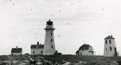
The current structure, the 3rd generation lighthouse and the 5th to be built on the island, was completed in 1915. It stands 60 feet tall and consists of a concrete, octagonal tower with a flashing white light. The tower stands at the center of the island, rather than nearer the edges like the previously paired lights. Unfortunately, the 1869 and 1877 towers were demolished since they were no longer needed.
As the lighthouse was automated in the 1970s, there is no longer a need for it to be manned 24/7. However, staffing the lighthouse is Canada's most obvious way of claiming sovereignty of the island. Canada could essentially declare international squatter's rights to bolster their claim.

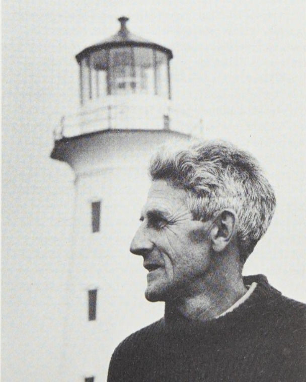
I had the pleasure of meeting one of the keepers when I visited in the summer of 2018. He showed me one of his binders of photos he's taken there over the years. It was amazing to see the crazy weather conditions and wildlife that the island sees through the seasons. He didn't seem to find the occupation lonely at all and seemed to enjoy talking with the visiting photographers and birdwatchers. He was, unsurprisingly, quite knowledgeable about the island's wild visitors, and gave us pointers on how to behave while we were there. One species of bird was nesting and liked to dive-bomb visitors' heads. The keeper gave us sticks to hold up to protect ourselves, while he himself just walked around with his hand on his cap, pointing skyward. I can picture him now walking around like that alone on the island.
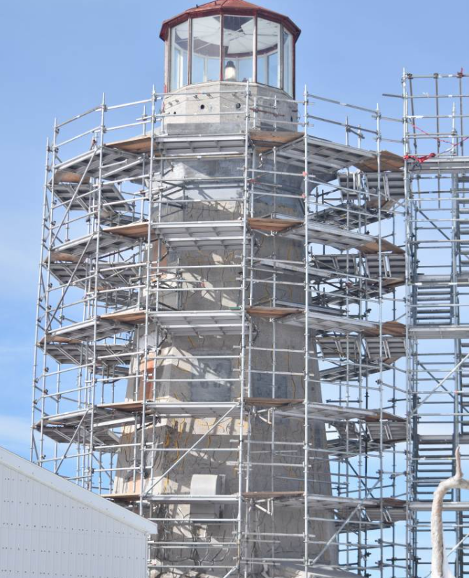
The 1915 lighthouse is protected under the Canadian Heritage Lighthouse Protection Act, passed in 2008. In more recent years, RJC Engineers was hired to conduct a large-scale restoration project of the light. The firm mitigated moisture intrusion and environmental deterioration.
Canada designated the island a migratory bird refuge in 1944, which is definitely deserved, as the island is home to one of the largest nesting colony of Atlantic puffins on the Atlantic coast. However, the US doesn't consider either the lighthouse or wildlife refuge designations to be relevant. The US also contends that it doesn't matter that Canada built, maintains, and staffs the lighthouse-it is still American soil in their eyes. Some Mainers are also quite sure on the subject. In fact, for many years a Mainer would annually install an American flag on the island. It wouldn't last long considering the island is always inhabited by a Canadian.
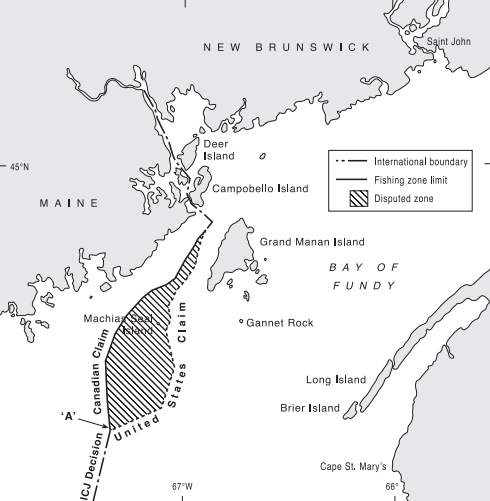
Despite the dispute, Maine and Canadian fishermen and lobstermen have coexisted relatively peacefully in the waters for generations. Tensions do occasionally rise over lobster, especially when the price of lobster goes up. 30 people are allowed to visit the island daily via boat, 15 from each country. There is 1 licensed tour company from each country allowed to take visitors to the island. These arrangements will likely carry on indefinitely unless one of the countries decides to force their ownership in some way. What do you think? Who do you think has the stronger claim?

Sources:
Island Soltaire, Film by Jungles in Paris
Network in Canadian History & Environment
The 'Gray Zone' Between the U.S. and Canada: Why This Murky Border Matters by National Geographic
Atlas Obscura
Lorimer, J. G. (1876) History of islands & islets in the Bay of Fundy, Charlotte County, New Brunswick. St. Stephen, N.B., Printed at the office of the Saint Croix courier. [Image] Retrieved from the Library of Congress, https://www.loc.gov/item/02000287/.
Keepers:
John Pendlebury (1832 – 1837)
John Conley (1837 – 1874)
Wright Edmondston (1874 – 1875)
Alexander Eddy (1875 – 1877)
David Webster (1877 – 1883)
Charles F. Seely (1883 – 1901)
Colin J. Ingersoll (1901 – 1904)
W. Lincoln Harvey (1904 – 1916)
Don C. Daggett (1915 – 1923)
S.B. Harvey (1923 – 1936)
Harvey Benson (1937 - 1940s)
Lawrence Benson (1960s)
Stan Green (1970s)
Jack Russell (1970s)
(not verified 1970s-1990s)
Ralph Eldridge (1996 - )
Barry Bagley (1996 - )


Comments